Larapinta Trail Homepage // Trail Snapshot / Trail Conditions / Facilities / Climate / Trail Grading System Larapinta Trail Facebook Page
There are 12 official trailheads along the Larapinta Trail. Alice Springs Telegraph Station trailhead (Section 1) is the official start point of the trail, while Redbank Gorge Trailhead ( Section 12) is the finish point. The trail officially heads in an east to west direction External Link, but hikers can go either way and start and finish at any trailhead. Most hikers start and finish from trailheads which are easy to access ( and is cheaper to pay for any drop offs and/or pick ups). Commercial transfers to remote trailheads can be expensive.
Key Points
Point 
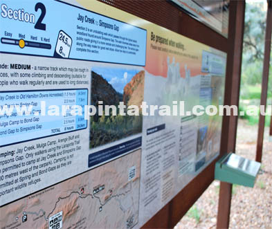
There are 12 official trailheads on the Larapinta Trail
Point Transfer operators provide drops/pick ups along most trailheads
Point 5 trailheads can only be accessed by 4WD
Point Finke River ( Section 11 Trailhead) cannot be accessed by vehicle
Point Standley Chasm (S4 Trailhead) has an entry fee
Point Jay Creek (Section 3) & Finke River ( Section 11) have large shelters
Point All trailheads have water tanks
Point Alice Springs Telegraph Station does not have campsite facilities
Point Section 1 Trailhead Start Point
Point Official Start Point of the Trail
Point Approx 4km from north of Alice Springs
Point 2WD vehicle access
Point Trailhead Type: Bow Shelter Only
More detailed Information
Point Section 2 Trailhead Start Point
Point Section 1 and 2 junction point
Point 24km west of Alice Springs
Point 2WD vehicle access
Point Trailhead Type: Large protected shelter
More detailed Information
Point Section 3 Trailhead Start Point
Point Section 2 and 3 junction point
Point Approx 76km north west of Alice Springs
Point 4WD vehicle access only
Point Trailhead Type: Large protected shelter
More detailed Information
Point Section 4 Trailhead Start Point
Point Section 3 and 4 junction point
Point Approx 50km west of Alice Springs
Point 2WD vehicle access
Point Trailhead Type: Information Shelter only
More detailed Information
Point Section 5 Trailhead Start Point
Point Section 4 and 5 junction point
Point Approx 70.4km west of Alice Springs
Point 4WD high clearance access only
Point Trailhead Type: Information Shelter only
More detailed Information
Point Section 6 Trailhead Start Point
Point Section 5 and 6 junction point
Point Approx 78.3.4km west of Alice Springs
Point 4WD high clearance access only
Point Trailhead Type: Large protected shelter
More detailed Information
 
Point Section 7 Trailhead Start Point
Point Section 6 and 7 junction point
Point Approx 90.4km west of Alice Springs
Point 2WD access. Gravel road.
Point Trailhead Type: Information Shelter only
More detailed Information
Point Section 8 Trailhead Start Point
Point Section 7 and 8 junction point
Point Approx100km west of Alice Springs
Point AWD access. Gravel road.
Point Trailhead Type: Large protected shelter
More detailed Information
Point Section 9 Trailhead Start Point
Point Section 8 and 9 junction point
Point Approx105km west of Alice Springs
Point 4WD access only.
Point Trailhead Type: Information Shelter only
More detailed Information
Point Section 10 Trailhead Start Point
Point Section 9 and 10 junction point
Point Approx 135km west of Alice Springs
Point 2WD access only.
Point Trailhead Type: Information Shelter only
More detailed Information
Point Section 11 Trailhead Start Point
Point Section 10 and 11 junction point
Point Approx 140km west of Alice Springs
Point No vehicle access
Point Trailhead Type: Large protected shelter
More detailed Information
Point Section 12 Trailhead Start Point
Point Official Finish Point of the Trail
Point Approx 160km west of Alice Springs
Point AWD/4WD vehicle access
Point Trailhead Type: Information Shelter only
More detailed Information
 
The Larapinta Trail Larapinta Trail Trailheads
Larapinta Trail Website
Disclaimer | Copyright | Privacy | Terms of Use | Webpage Updated April 2016
© World Expeditions 2024